REonomy’s Innovative Launch with Virtual Earth
 The Knowledge of Real Estate – REonomy – launched May 1 leveraging Microsoft Virtual Earth as the first online information provider to integrated parcel data and comprehensive property research tools with a MLS and advanced marketing tools in one location (press release). REonomy.com serves the needs of real estate professionals industry-wide, including brokers, agents, development/management companies, lenders, third-party analysts, and private equity firms, among others.
The REonomy site is locked down for registered users, but they gave me special access and permission to share what’s on the inside with you. I’ll focus on the mapping components, since that’s what I care about, but it should be known that this site is jam-packed full of features for agents, brokers and the like so it should be interesting for those of us not in real estate to get a look on the other side of the proverbial fence.
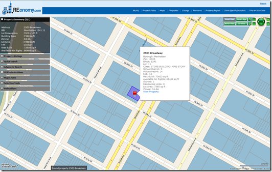
Once you get to the map-based listings page you get a plethora of information about properties (specific to New York and New Jersey). First, they’ve implemented their own custom navigation bar and moved it to the upper right. It includes links for all map styles and the 3D map mode, plus navigation features for rotation, panning and zooming. Now, zoom in and you’ll see the parcel layers load as a raster overlay. This is where the brilliance begins, so I’ll explain how this works in a minute. If you click on any parcel REonomy looks up the parcel in question, highlights it, provides the address and property information, drops a pin at the center of the property and creates an enhanced roll over (ERO) with additional information and a link to view the property. How’s that for a robust, exploratory user experience?
So, how is this done….well, here’s what they could be doing…first, they generate a tile layer based on parcel data that aligns with the Virtual Earth tile pyramid (which, by the way, the MSDN technical article was recently updated to include pixel to lat/lon conversion sample code). They overlay this using map.AddTileLayer(). Next, when you click on the parcel, you’re actually clicking a pixel on the screen. Catching the right mouse click event, they’re firing off a method to reverse the pixel to a lat/lon (map.PixelToLatLong()) which gives them a coordinate that they can send to their spatial database. They look up which polygon the point resides in (in this example the polygon is a parcel), grab the vertices of the polygon and renders the polygon and a pushpin on the map using map.AddShape(). Also, with the spatial query, they identify the polygon in which the point resides and pull all the respective information out of the database about that parcel and push it into the DIV (hovering over the map) and ERO. Awesome and very intuitive!
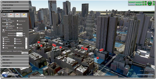
Next, I tried the “Advanced Search” which allows you to select the Property Type – Residential or Commercial; Availability Type – Sale or Lease; Area Range applies to – Property or Listing; square footage and a boatload of amenities (including Door Man! I <3 NY). When I searched, the results produced a number of results pinned to the map, the parcel overlays, the properties that were returned had their parcels highlighted on the map and the enhanced rollovers were populated with property information and linked off to view the property. This alone was fantastic, but when I switched to 3D and loaded the high resolution, scaled, textured models included with Virtual Earth’s platform well, the result was stunning. You’ll notice the parcels are still highlighted under the buildings and the pins remain intact and tied to the top of the respective properties. What’s great about all of this is that they didn’t really have to do any extra work – as you develop in 2D, viewing your data in 3D is flipping one bit native to the AJAX control!
All in all a fantastic set of functionality and a new showcase for my on stage demos. I guess my only feature request would be to not use our ugly red pins. The site is marvelous and our red pins really do it an injustice. Also, how cool would Photosynth look on this site? Am I greedy? Gordon Gecko says greed is good and it works, so I’m going with that.
CP

