Visualizing Swine Flu on Virtual Earth
What the heck is going on with this swine flu thing? I was in the elevator at The Roosevelt last night and these guys are saying, “Don’t eat the carnitas (pork) no matter what.” Um, I don’t think you can get this new swine flu from eating pig, but apparently you get from any other normal means of transmitting any other flu strain – hand shaking, kissing, swapping spoons, etc. I’m buying stock in Purell. Well, while there’s quite a bit of information available about this swine flu some Microsoft Virtual Earth fans decided to map the outbreak, so here are a couple applications using Virtual Earth to visualize the outbreak.
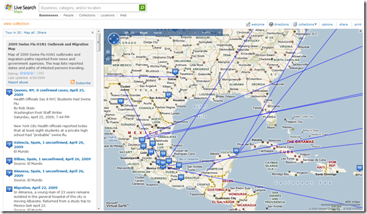
 Live Search Maps has a collection highlighting reported cases (both confirmed and unconfirmed) and the routes they traveled between home and vacation / business where they apparently contracted the strain. The collection also has information about each point on the map. The official description is, “2009 Swine Flu H1N1 Outbreak and Migration Map - Map of 2009 Swine Flu H1N1 outbreaks and migration paths reported from news and government agencies. The map lists reported dates and paths of infected persons traveling.”
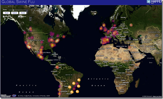
 UMapper built out a version of the swine flu data which overlays raster tiles on Virtual Earth and renders it through a Flash interface. The heat map (which gets updated a few times through the day) shows the impact of the outbreak around the world where the hot areas are white at the center cooling off to orange and purple. You can how the flu has really taken off in North America as would be expected since the claim is that it originated in Mexico. Using the heat map, one could argue that it may have started in the US given the intensity in the respective areas. Perhaps the pigs were eating peanuts out of Georgia? Hmm. The UMapper map is embeddable so you can actually embed the application right in your own web page. I’ve embedded the mashup below, so be patient as it loads….
Bo Zhao, a University of Florida student, build out a sweet UMapper Swine Flu mashup on Geoinformatics.cn in Flash that includes the heat map mentioned previously, but also includes pins indicating flu outbreaks and sweet animations if there are multiple pins in a single location. You can switch map styles and toggle the pins on the map.
So, pretty much the same rules apply to any other flu…wash your hands, use Purell and don’t let anyone sneeze, breathe or spit on you…if you can help it. So, in the famous words of Jules Winnfield, “I just don’t dig on swine.”
CP
Comments
Anonymous
April 29, 2009
Condition by Condition: Natural, Safe and Effective Treatments Are you looking for specific information about an alternative health treatment for an infectious condition? If so, this section of the website is for you. http://www.guardian-silver-health-supplements.com/natural-alternative-health-treatments/Anonymous
April 29, 2009
we can put swine flu in this Perceptive http://www.guardian-silver-health-supplements.com/viral-infections/swine-flu/Anonymous
April 30, 2009
The comment has been removedAnonymous
April 30, 2009
Colonial Medical Supplies just received new shipment of 3M N95 Masks. All of our distributors are already out of stock. Once current stock is sold any additional shipments will be delayed. Masks can be purchased at any one of our 3 retail locations or online at www.colonialmed.comAnonymous
May 02, 2009
Funny t-shirts on swine flu! Yes, swine flu is a sad thing, and we all want to see it stopped, but heh, you still need to be able to keep a happy spirit no matter what. Check em out: http://www.davesdailydose.com/?s=swine+flu

