How to Integrate Virtual Earth Maps with a SharePoint List
 Hi everyone,
My name is Greg Chan and I’m a Program Manager in the SharePoint Designer team. I’ve also been involved in the development and testing of the Application Templates for Windows SharePoint Services 3.0. Just a couple weeks ago, I attended Tech Ed in Orlando and presented a breakout session called "Designing and Building Sophisticated Composite Applications with Microsoft Office SharePoint Designer 2007".
Today, I’ll show you how to integrate the Virtual Earth Map control with your SharePoint list.This is actually part of the demo I gave in Tech Ed, and it has generated a lot of interest. Many of you have requested more information on this, so as promised, I’m dedicating this post to it. Some of you may be wondering… "Isn’t this the same as the Plotting Your Data Using Virtual Earth blog that Jon Campbell posted awhile back?" While there are overlaps, the key difference is that this post will talk about plotting a single address as opposed to multiple addresses. A big benefit for doing single address is that Virtual Earth is good at plotting a single address without the need for longitudes and latitudes. We simply need to pass in the address value and take advantage of functions provided by Virtual Earth to geocode it. (I don’t know about you, but when I search for driving directions, I’m not typing in longs and lats...)
Let's get started!
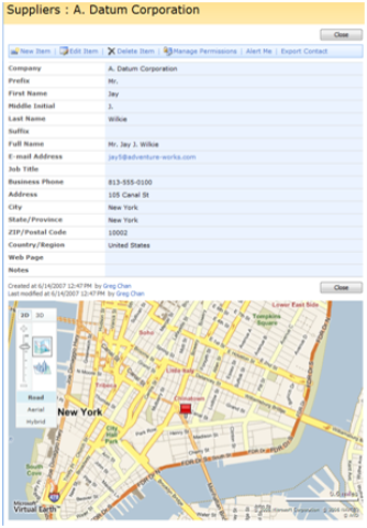
Here’s the scenario -- you own a bike shop and use a SharePoint site to manage the manufacturing process for building bicycles. In your site, you have a Suppliers list that stores information about each of your supplier like phone number, address, e-mail, etc. The list is based off the Contacts list. You want to insert a map control inside the display form for each supplier to show the location of the supplier.
Step 1 - Modifying the Display Form
Open in SharePoint Designer the display form (DispForm.aspx) of the SharePoint list containing the address information. Then, we want to use the data view to generate the map. (Yet another reason why we call data view the swiss army knife of web parts...) Below are the detailed steps to do this:
- In SharePoint Designer, open up DispForm.aspx under the Suppliers folder.
- Bring up the Data Source Library task pane.
- Select the Suppliers list and drag it onto the design surface, below the default list form controls.
- Bring up the Common Data View Tasks menu for the data view.
- Pick the Filter option.
- In the Filter Criteria dialog:
- Field Name = ID
- Comparison = Equals
- Value = Create a new parameter
- In the Data View Parameters dialog:
- Name your parameter (i.e. SupplierID)
- Parameter Source = Query String
- Query String Variable = ID
- Default Value = 36 (optional, I prefer to enter a # that maps to an item that I know already exists in my list)
- Hit OK and OK.
Note - All standard SharePoint forms contain an ID parameter in the query section of the URL:
Each item in a SharePoint list is mapped to a unique ID value. This ID value is what we're using to filter the data view.
As a result, we’ve just inserted a data view of the suppliers list that is filtered down to show ONLY the current supplier and not all other suppliers. Right now, the data view is still rendered as a table by the default XSLT. Next step, we’re going to write custom XSLT and JavaScript to format the data view as a map!
Step 2 - Use custom XSLT + JavaScript to create Virtual Earth Map control
In order to create the Virtual Earth Map control, we’ll need to utilize some JavaScript functions provided by the Virtual Earth SDK. Below are JavaScript snippets that we need.
Load the map
var map;
// Loads the Virtual Earth map control
function loadMyMap() {
map = new VEMap(&'myMap');
map.LoadMap();
map.FindLocation '<xsl:value-of select="@WorkAddress" />, <xsl:value-of select="@WorkCity" />, <xsl:value-of select="@WorkState" />, <xsl:value-of select="@WorkZip" />', displayPushPinCallBack);
}
FindLocation() will take the address values passed in and center the map to that location. This is a great function! For the function parameters, we’re passing in the XSL values of the Address, City, State and Zip Code field of the supplier.
Add the pushpin
function displayPushPinCallBack() {
var pin = new VEPushpin(
1,
map.GetCenter(),
null,
"<xsl:value-of select="@Title" />",
''
);
map.AddPushpin(pin);
}
GetCenter() will return the longitude and latitude values of the center of the map, which is currently the location of the address you passed in from FindLocation() . We’re also passing in the XSL value of the Title field of the supplier.
The entire XSL stylesheet
Here’s the entire XSL that we will use to format the data view into a Virtual Earth Map control.
<?xml version="1.0" encoding="utf-8" ?>
<xsl:stylesheet version="1.0" xmlns:xsl="https://www.w3.org/1999/XSL/Transform">
<xsl:output method="html" indent="no"/>
<xsl:template match="/">
<xsl:call-template name="dvt_1"/>
</xsl:template>
<xsl:template name="dvt_1">
<xsl:variable name="Rows" select="/dsQueryResponse/Rows/Row" />
<xsl:call-template name="dvt_1.body">
<xsl:with-param name="Rows" select="$Rows" />
</xsl:call-template>
</xsl:template>
<xsl:template name="dvt_1.body">
<xsl:param name="Rows" />
<!-- Link to the Virtual Earth Map control JS file -->
<script src="https://dev.virtualearth.net/mapcontrol/v4/mapcontrol.js">
</script>
<xsl:for-each select="$Rows">
<xsl:call-template name="dvt_1.rowview" />
</xsl:for-each>
</xsl:template>
<xsl:template name="dvt_1.rowview">
<div id='myMap' style="width:650px; height:400px;"></div>
<script type="text/javascript">
_spBodyOnLoadFunctionNames.push(" loadMyMap ");
var map;
// Loads the Virtual Earth map control
function loadMyMap() {
map = new VEMap('myMap');
map.LoadMap();
map.FindLocation('<xsl:value-of select="@WorkAddress" />,
<xsl:value-of select="@WorkCity" />,
<xsl:value-of select="@WorkState" />,
<xsl:value-of select="@WorkZip" />', displayPushPinCallBack);
}
function displayPushPinCallBack() {
var pin = new VEPushpin(
1,
map.GetCenter(),
null,
"<xsl:value-of select="@Title" />",
''
);
map.AddPushpin(pin);
}
</script>
</xsl:template>
</xsl:stylesheet>
- _spBodyOnLoadFunctionNames() adds a function to the onload event of the body element. This ensures that loadMyMap() is called whenever the display form is loaded. The Using Javascript to Manipulate a List Form Field blog has a more detailed description of this.
- The actual XSL is pretty basic. We’re simply using XSL to generate the <div> container for the map control and also passing in XSL values for the JavaScript function calls.
Next thing you'll want to do is take that entire XSL stylesheet and save it out as a separate XSL file. This will make things a lot cleaner and easier to manage. We'll save this out into a file called LiveMaps.xsl, and store it in the folder for the Suppliers list, along with the DispForm.aspx.
Step 3 - Format the data view using LiveMaps.xsl
Now we want to use LiveMaps.xsl to render the data view.
- Go back to DispForm.aspx in SharePoint Designer.
- Right-click on the data view, which is a Data Form Web Part.
- Select Web Part Properties.
- Expand the Miscellaneous category.
- For XSL Link, click on the button to the right of the input field.
- Navigate to the LiveMaps.xsl file and select it.
 All Done!
Back on the browser, when you go to the display form of any supplier, there’ll be a great map view that will show you the location of the supplier. You’ll be able to interact with the map, just like you would on https://local.live.com.
Thanks,
Greg
Comments
Anonymous
June 26, 2007
Thanks for your code but I am having problems getting the actual map to display. The variables are coming through correctly but I am getting "// Link to the Virtual Earth Map control JS file" showing up on the page. Is there something missing in the code?Anonymous
June 26, 2007
PingBack from http://www.protocol16.com/2007/06/26/mapping-inside-sharepoint-2007-moss/Anonymous
June 26, 2007
Has anyone been able to get this to work as written? I'm trying it, but the map isn't displaying. All the configuration went well, and when I view the source, the right parameters are loading into the JavaScript portions of the XSL. I'm just not seeing the map.Anonymous
June 26, 2007
The comment has been removedAnonymous
June 26, 2007
Thanks for the clue on the coding Ricky. That did the trick to get the map to show but now I get the map covering the entire page and not limited to the div. Any thoughts?Anonymous
June 27, 2007
'How can the code render the virtual eartch map"? Is it some javascript? Which will only render when connected to the internet? I tried get it to work on a vpc which isn't connected to the internet..can that make any difference? regards JoostAnonymous
June 27, 2007
Siguiendo con la recopilación de recursos iniciada en un post previo , en la nueva entrega de recursosAnonymous
June 28, 2007
Joost - You are correct. This just uses javaScript to dynamically pass information to the Live Maps server. The user viewing the page must have access to the Internet in order for the browser to make the call to the server. Steven - I don't have any idea why yours is showing up that way. Sorry.Anonymous
June 28, 2007
This is a great tip and saw it in action twice at TechEd. I just had a chance to try it myself and seems i have missing something. I am not getting the map but instead a message saying // Link to the Virtual Earth Map control JS file, I am wondering is someone got this error when trying this.Anonymous
June 28, 2007
The comment has been removedAnonymous
June 28, 2007
The comment has been removedAnonymous
June 28, 2007
The comment has been removedAnonymous
June 28, 2007
Steven - Though it shouldn't be necessary anymore, I previously had to set the "overflow:hidden" css attribute in the style for the myMap div. Try that and see if it gets you going.Anonymous
June 28, 2007
The comment has been removedAnonymous
July 07, 2007
Here is another take on displaying the map in a Web Part page using a connection from a list of addresses http://www.wssdemo.com/demo/default.aspxAnonymous
July 12, 2007
Buchtipps Microsoft Office SharePoint Server 2007 - Das Handbuch von Bill English Beginning SharePointAnonymous
July 12, 2007
Direkter Download: SPPD-074-2007-07-12 [00:00] Intro [00:00] Buchtipps Microsoft Office SharePoint ServerAnonymous
July 12, 2007
Direkter Download: SPPD-074-2007-07-12 [00:00] Intro [00:00] Buchtipps Microsoft Office SharePoint ServerAnonymous
July 30, 2007
Hi, This is awesome stuff. I am getting it to work for US locations, however I can't seem to figure out what's going on with the Canadian locations. Any help would be appreciated. Thanks.Anonymous
August 01, 2007
The comment has been removedAnonymous
August 06, 2007
Thanks Jon, that did the trick.Anonymous
August 13, 2007
The comment has been removedAnonymous
August 27, 2007
Thanks Greg!!! Got it working and my peers and co-workers love it. It makes me look like a genius!!Anonymous
September 12, 2007
Thank you very much for this post. We are actually Feeding the data view with BDC fields from our office locations database. Great feature for our corporate intranet. Thanks again.Anonymous
September 20, 2007
I am not able to get this working. I get "this web part doesnt have a valid XSLT style sheet...". Any ideas? ThanksAnonymous
September 21, 2007
The comment has been removedAnonymous
September 24, 2007
it's broken.... :(Anonymous
October 02, 2007
Is there a function that will allow the user to get driving directions in the map control on the SharePoint list?Anonymous
October 04, 2007
Anyone can tell me how i can add more than one pin (meaning more records) into the map under sharepoint? Thanks.Anonymous
October 05, 2007
Nick recently blogged about a new web part available for users of his BDC Meta Man tool that allows usersAnonymous
October 05, 2007
Nick recently blogged about a new web part available for users of his BDC Meta Man tool that allows usersAnonymous
October 08, 2007
Works great.Anonymous
October 12, 2007
Very Cool... ThanksAnonymous
October 13, 2007
Microsoft's Virtual Earth technology powers the maps on Live Search and many other web-based applications,Anonymous
October 22, 2007
Nice sample and walkthrough. I would like to build this into a contact list and then save the list as a template, so all new contact lists on the site have the functionality available. However, the map data view has the original List ID hardcoded from designer. How can I make the List ID a parameter (similar to the record ID) so it can be changed dynamically and context sensitive to the calling list? The List ID is not located int he URL, so can it be bound from a different location?Anonymous
October 22, 2007
Just found the answer to my previous question, so I thought I would share. When the data view is created, the List ID is bound to a hardcoded default value. Simply modify the parameter binding so the correct List ID is acquired from CAML. This appears to work OK in the limited testing I have performed thus far... From <ParameterBinding Name="ListID" Location="None" DefaultValue="..."/> To <ParameterBinding Name="ListID" Location="CAMLVariable" DefaultValue="CurrentListID"/>Anonymous
October 25, 2007
I'm still doing something wrong. I don't have much experience with SharePoint designer but this demo looked pretty easy. I'm still getting "Unable to display this webpart." Maybe I did something wrong when I added the data viewAnonymous
November 01, 2007
Simon: check out http://blogs.msdn.com/sharepointdesigner/archive/2007/05/23/plotting-your-data-using-virtual-earth.aspx?CommentPosted=true#commentmessage Chad E/Shankar: I just answered the driving directions question in the comments of the above post - i that should get you going. This code should still work just fine, but I will verify. There have been a few changes between v4 and v6 (the current release of VE as of today) - check out http://dev.live.com/virtualearth/sdk/ for more info. They have a link that indicates what is new.Anonymous
November 06, 2007
Thanks Jon- that worked !!Anonymous
November 15, 2007
Works great, pretty easy. If I'm not using a contact list, but a custom list I just need to change the variables names in the map,FIndLocation() right? The page is showing a VE error for the address, including "<div>" in the address, any help here? THe name of the pinpoint is defined by what variable in the code?Anonymous
November 15, 2007
Any tip on how to display all pinpoints from the list?Anonymous
November 20, 2007
Daniel: for plotting multiple points, check out http://blogs.msdn.com/sharepointdesigner/archive/2007/05/23/plotting-your-data-using-virtual-earth.aspx#comments. I am in the process of putting something together that is new and improved for all those people wanting batch geocoding, so stay tuned. As for your question about the pushpin - function displayPushPinCallBack() { var pin = new VEPushpin( 1, // this is the ID of the pushpin. you can use it modify the pushpin via javascript later if you want to, but for most people this is just something you have to set. When you are displaying multiple pins you should be sure that this is unique. map.GetCenter(), // this is where you want the pushpin. since findlocation sets the center of the map over your address, you can use GetCenter() to grab the coordinates. null, // the custom icon for your pushpin (i think). note that this has changed in the current SDK "<xsl:value-of select="@Title" />", // this is the title/name of your pushpin. you can put whatever you want here '' // this is the description of your pushpin. you can put whatever you want here - images, text, links, tables, etc. I have even hosted an iframe here with a little effort. ); map.AddPushpin(pin); } If you want to change the title or description as shown in the popup, just dump in the appropriate fields or text into the spaces i mention above and you should be good to go.Anonymous
November 27, 2007
The comment has been removedAnonymous
November 29, 2007
I resolved the issue I had and posted on the 20th. I changed the script to v6, removed the pushpin and added layers.Anonymous
December 05, 2007
The comment has been removedAnonymous
December 30, 2007
Any chance you can upgrade this code for V6?? I am attempting ... can load the map but still working on the pushpins. Thanks!Anonymous
January 09, 2008
Direkter Download: SPPD-074-2007-07-12 [00:00] Intro [00:00] Buchtipps Microsoft Office SharePoint ServerAnonymous
January 22, 2008
I can't get this to work with V 6 either. some tips would be greatly appreciated. DeanAnonymous
January 28, 2008
I got it to work with V6 -- make sure that your id='myMap' is not changed to {generatedID}. But, when I mouseover my pin the popup is not displayed next to the pin. The popup for the title and description is displayed outside of my VE map. Any ideas? ThanksAnonymous
February 07, 2008
The comment has been removedAnonymous
February 08, 2008
I have one task I'd love to take on and I'm not certain how to harvest the information and return the results onto a VE map using WSS data. I re-wrote the xsl above for v6 and it's doing what I want for one data record. What I want to do is take a small list of several projects which include address data and plot them on a VE map but the above code only works with one record. Is there a way to pin multiple entries on a single map using WSS data? Please let me know awclayton77@msn.com Thanks in advance!Anonymous
February 13, 2008
Anthony - That question comes up a lot. The basic gist is to use something similar to http://blogs.msdn.com/sharepointdesigner/archive/2007/05/23/plotting-your-data-using-virtual-earth.aspx#comments combined with elements of this post as well. My suggestion would be to use the following formula:
- start with your map hidden, perhaps with a loading image or something
- Use a DFWP to generate an array of javascript structures, one for each address
- call findlocation for the first address, specifying a callback that stores the lat/lon
- in the callback, if there are more points to plot then call findlocation on the next point
- if no more points are left, then plot them all Its not ideal, but it does work. The best solution would be to use some custom code to agressively cache the geocoded points and re-use that data when possible, but the above process should work for those without the ability to deploy custom code.
Anonymous
February 14, 2008
I need immediate help in getting this working. I get "this web part doesnt have a valid XSLT style sheet getting Live SSL from Server". Any help is highly appreciated. Thanks in advance.Anonymous
February 20, 2008
I was able to plot multiple lists directly from a SP List vs. XML list using Jon Campbell's help at http://blogs.msdn.com/sharepointdesigner/archive/2007/05/23/plotting-your-data-using-virtual-earth.aspx Essentially I built the page as he states but substituted the XML data source with a data source library list from my SP site and it worked. Thanks again to all.Anonymous
March 26, 2008
Hi folks. This is Greg Chan, Program Manager in the SharePoint Designer team. For those of you who attendedAnonymous
March 28, 2008
Mine is blowing out the div and going full screen... Anyone have this issue and resolve it?Anonymous
April 01, 2008
Dave: A common reason for the map to go full sceen is when the "overflow:hidden" is not set. Try setting that on your map's div - it may solve the issue.Anonymous
April 02, 2008
I would like to know if there is a way to intergrate your outlook contact list to the Virtual Earth so when you update the contact list it updates the collection on Virtual Earth. Anyone have any ideas on how this is done?Anonymous
April 07, 2008
HI all .. i need help i am working on the look and feel of the page . what i have done is i have copied a default theme(verdant)and made changes to the Cust1011-65001.css and replace the content of "C:Program FilesCommon FilesMicrosoft Sharedweb server extensions12TEMPLATETHEMESCustomBrowntheme.css the changes are seen when the changes are made but when i replace the content of "C:Program FilesCommon FilesMicrosoft Sharedweb server extensions12TEMPLATETHEMESCustomBrowntheme.css and when perform the application pool recycle of that web application and when i opened the Cust1011-65001.css file the number of lines of code got increased by itself and copy of ms-pagetitle was seen with the default url of the image even after mnaking the changes again and again please help shiva.....Anonymous
April 12, 2008
I have been using the Virtual Earth control a lot lately for various demos, mostly by putting customizedAnonymous
April 15, 2008
Michael - What you are describing is basically what is presented in the other mapping post on this blog - http://blogs.msdn.com/sharepointdesigner/archive/2007/05/23/plotting-your-data-using-virtual-earth.aspx. You would need to have your contacts list sync'd up with a sharepoint contacts list, and then plot that sharepoint list. Since you will need geocoding, check my response to anthony's question on how to get that done for a list.Anonymous
April 15, 2008
Hey Guys, I guess some of you guys have problem loading the map even following everythiong in the blog. It seems that the _spBodyOnLoadFunctionNames.push(" loadMyMap "); doesn't work at times. So I replaced that code with "function addLoadEvent(func) { var oldonload = window.onload; if (typeof window.onload != 'function') { window.onload = func; } else { window.onload = function() { oldonload(); func(); } } } addLoadEvent(loadMyMap); " And this worked for me. Hope this helps. Thanks NakulAnonymous
April 18, 2008
The comment has been removedAnonymous
April 25, 2008
Jon, Thanks for pointing out the reason why _spBodyOnLoadFunctionNames doest work. I observed one more thing if I use this code and browse it using Safari, I don't see the map at all. I am not able to figure out what seems to be the reason.Anonymous
May 30, 2008
Great job but my job is slightly different that i have to show the offices of a company that r in my share point list. like if i have to show of the US offices of the company,then i have to show the address in map of that particular office. plz help me Regards RamAnonymous
June 17, 2008
Ram - This post should get you most of the way to what you want. If I understand you correctly, you are wanting to have the address shown with the pushpin in the popup that comes up? If so, then you want to modify the VEPushPin javascript call. The last two arguments are the title and description, respectively, which are displayed in the popup that is shown when you hover over the pushpin for the location. The code above sets the title to be the Title field (which is really the last name) and the description to be blank. You just need to change those last two arguments to reflect your desired behaviorAnonymous
June 17, 2008
Hi, thats really cool and exactly what I need for a showcase. I got this to work straight a way. But know I'm trying ot re-build this for the second time and it doesn't work. Does someone have any idea what might be wrong? I think I haven't changed anything. Regards JanAnonymous
July 14, 2008
Jan - I would suggest taking this code and translating it to the lates version (6.1 as of today) of the sdk (http://dev.live.com/virtualearth/sdk/). That might work better for you, and it should be a pretty straight forward task.Anonymous
July 16, 2008
Almost there- it seems great so far! Im getting an error when opening the display page. A map loads but it is only a map of the US, not a specific address. Here is what the error says: The server is temporarily unavailable. Try again late. Is this really a temporary error?Anonymous
July 16, 2008
Solved my problem. I had changed the xpaths thinking that it was causing a previous error. For example I made @WorkAddress just @Address and etc..Anonymous
July 17, 2008
Hello Jon rather than using the xml as a data source for the grid view,i have to use SQL as a data source Is this possible? Please help me Ram SharmaAnonymous
July 18, 2008
Ram - You can use any of the datasources that are supported by the DataFormWebPart, which means most ASP.Net DatasSourceControls. If you are using a SQL datasource then you will want create a DataView of your SQL data source, then adapt the above xsl to meet your needs. The main thing you will need to change are the <xsl:value-of /> calls to make sure that they refer to the appropriate fields in your sql datasource. There are a couple ways to do this, but an easy way is to insert a table view of your data, then look at the xsl in order to find the columns you want.Anonymous
July 20, 2008
Hi Jon Thanks for your reply, i have created data view of my SQL data source by following these steps:
- Created a data table in SQL having columns name lat,long,name and description 2 Create a aspx page SP designer and write down the functions like GetMap,AddPin etc 3 open data source library from the task pane and expand Data Source Connections and connect to my data base that SQL data base. 4 and then right click the data source that appear in data source library,click on show data and it shows me the data' But as you kindly said in your reply"then adapt the above xsl to meet your needs" and "The main thing you will need to change are the <xsl:value-of /> calls to make sure that they refer to the appropriate fields in your sql datasource."i am getting these point Please guide me Regards Ram Sharma
Anonymous
August 01, 2008
First off, Great Post!! I actually took this code and hooked it into a BDC connection. Now for my issue. I am getting an popup each time this page is loaded saying that “This page contains both secure and nonsecure items". I thought I could fix this by changing the "Mixed Mode" setting in IE but it did not fix it. Any thoughts on what I can do to prevent this popup?Anonymous
August 06, 2008
John - This blog post should help fix your problem - it sounds like you are using https/ssl or whatnot. You basically need to use an ssl path to get to the map javascript. try changing http://dev.virtualearth.net/mapcontrol/v4/mapcontrol.js to be https://dev.virtualearth.net/mapcontrol/v4/mapcontrol.js. However, you should probably update the code to use the v6 api since VE seems to be retiring some of their older versions. http://weblogs.asp.net/davidbarkol/archive/2007/11/23/ssl-support-for-virtual-earth-is-here.aspxAnonymous
August 20, 2008
SharePoint Designer 2007 Getting to know the Data Form Web Part (1 of 4) SharePoint Designer 2007 HandbuchAnonymous
August 20, 2008
Hi All, Gregg, Great post.. I have implemented this in a contact management application. In that application I have the prospects identified by several key parameters. These parameters are then used to group the prospect detail records. At the present time, the VE control adds pins to the entire list as defined by the number of total prospects returned by a given view. Now, each prospect view contains collapsed groups, based on the key parameters mentioned above. I have two additional actions I need the mapping to include, and wonder if anyone here can point me to the appropriate pace to research: 1. I would like to have the VE control map only the expanded group details. 2. I would like to vary the color/type/size of pin used based on key values contained in each contact details. Again, any help/direction for research would be a ppreciated. Thank You.Anonymous
August 20, 2008
SharePoint Designer 2007 Getting to know the Data Form Web Part (1 of 4) SharePoint Designer 2007 HandbuchAnonymous
August 28, 2008
LISpeedyG - What you are describing for #2 is essentially conditional formatting. You will need to modify the XSL mentioned in the article to make it happen, but it can be tricky. function displayPushPinCallBack() { var pin = new VEPushpin( 1, map.GetCenter(), null, <------------- this argument controls the icon "<xsl:value-of select="@Title" />", '' ); Basically you would use either xsl:if statements or an xsl:choose block to pick which pin icon you want based on your requirements. For example, lets say you have 3 icons: 1.png, 2.png, and 3.png. The code might look like this: function displayPushPinCallBack() { var pin = new VEPushpin( 1, map.GetCenter(), <xsl:choose> <xsl:when test="@Rating=1">"http://mysite/images/1.gif"</xsl:when> <xsl:when test="@Rating=2">"http://mysite/images/2.gif"</xsl:when> <xsl:when test="@Rating=3">"http://mysite/images/3.gif"</xsl:when> </xsl:choose>, "<xsl:value-of select="@Title" />", '' ); I'm not sure I follow your first question, but if you are wanting to modify what is shown in the popup dialog, then its the same process: function displayPushPinCallBack() { var pin = new VEPushpin( 1, map.GetCenter(), null, <------------- this argument controls the icon "<xsl:value-of select="@Title" />", <----- this argument controls the title '' <--------------- this argument controls the description );Anonymous
September 05, 2008
Anyone got this working on Firefox?Anonymous
September 10, 2008
Actually using position:absolute in the style attribute, makes the map display correctly in FF <div id='myMap' style="position:absolute; width:635px; height:220px;"></div> <script id="myMap" style="position:absolute; width:635px; height:220px;">Anonymous
October 02, 2008
I implemented this and it was all working fine until a couple of weeks ago. Has there been a change to the map control API that I need to account for in the xsl code?Anonymous
October 02, 2008
Hi, could someone possibly update the code to use the new version of the script (http://dev.virtualearth.net/mapcontrol/mapcontrol.ashx?v=6.1)? The code above, as is, does not work. The web part is blank. if I change the script to the above mentioned, I get errors and sometimes i get the map of U.S. but no address plotted on it. Any help would be greatly appreciated. ThanksAnonymous
October 14, 2008
The comment has been removedAnonymous
November 20, 2008
The blog mentioned here basically talks of integrating Virtual earth maps with a contact list. The display form of the list is modified to show the map. But i beleive this method will create deployment issues ,we obviously cannot ask a client to do such configurations.Can we export these configurations in any way?? Instead what we did recently we created a custom webpart that accesed the location details like the dataview webpart and passed them to virtual earth Now we created a custom list definition and in its dispform.aspx we added this webpart... The biggest advantage was that any in no of instances of the list could be created and will require no configuration at all... If there any other workaround...do suggestAnonymous
December 09, 2008
The comment has been removedAnonymous
December 18, 2008
The comment has been removedAnonymous
December 19, 2008
The comment has been removedAnonymous
January 01, 2009
Un año más ( ¡FELIZ AÑO NUEVO A TODOS! ), aquí estoy dando guerra (y ya van más de dos desde que RodrigoAnonymous
February 22, 2009
Referring to Greg's original xsl listing above (many thanks by the way), if you change what I've outlined below, it seems to be working now. Change from this: <script src="http://dev.virtualearth.net/mapcontrol/v4/mapcontrol.js"> </script> To This: <script type="text/javascript" src="http://dev.virtualearth.net/mapcontrol/mapcontrol.ashx?v=6.2"> </script> Also, change this: map.FindLocation('<xsl:value-of select="@WorkAddress" />,<xsl:value-of select="@WorkCity" />,<xsl:value-of select="@WorkState" />,<xsl:value-of select="@WorkZip" />', displayPushPinCallBack); To This: map.Find(null,"<xsl:value-of select="@WorkAddress" />,<xsl:value-of select="@WorkCity" />,<xsl:value-of select="@WorkState" />,<xsl:value-of select="@WorkZip" />",null,null,null,null,null,null,null,null, displayPushPinCallBack) Also, change this function: function displayPushPinCallBack() { var pin = new VEPushpin(1,map.GetCenter(),null,"<xsl:value-of select="@Title" />",''); map.AddPushpin(pin); } To This: function displayPushPinCallBack() { var shape = new VEShape(VEShapeType.Pushpin, map.GetCenter()); map.AddShape(shape); } I found these resources to be especially helpful: MSDN http://msdn.microsoft.com/en-us/library/cc879134.aspx and the Virtual Earth interactive SDK http://dev.live.com/Virtualearth/sdk/# Cheers MikeAnonymous
March 16, 2009
Please Help I've gone through this 3 times. when i attach the xsl file, everything loads but no map appears. I know its working correctly because my sharepoint site is https:// and I'm using another VE map elsewhere that prompts me with the same message "this page contains secure and unsecure......" everything is in the correct spots - if i remove the xsl link i get the dataview where the map should be poping up - I'm lost? PS - I updated the code to VE 6 - but either way 4 or 6 the same thing happens even after I've gone thorugh every suggestion (including the fact my default.master is customized - tried that fix also!!!)Anonymous
March 23, 2009
Great post! Thanks to all who have contributed to a valuable resource. http://sharepointuzma.wordpress.com/Anonymous
April 02, 2009
I've created an updated XSL file you can use with the Virtual Earth 6.2 API. You can grab it off my new blog post: http://blogs.microlinkllc.com/tresing/archive/2009/04/02/virtual-earth-6-2-in-sharepoint.aspx -TomAnonymous
April 24, 2009
Hi guys, I am trying to use the following XSL for transform the coreresults web part in MOSS. I add metadata property mappings for lat and long in central admin then use the follwoing XSLT: However I get a blank DIV with no results any ideas: <xsl:stylesheet version="1.0" xmlns:xsl="http://www.w3.org/1999/XSL/Transform" > <xsl:output method="html"/> <!-- This template is called for each result --> <xsl:template match="Result"> <xsl:text>AddShape(</xsl:text> <xsl:value-of select="lat"/> <xsl:text>,</xsl:text> <xsl:value-of select="lon"/> <xsl:text>,"</xsl:text> <xsl:value-of select="title"/> <xsl:text>");</xsl:text> </xsl:template> <!-- XSL transformation starts here --> <xsl:template match="/"> <div id="myMap" style="position:relative; width:400px; height:400px;"/> <xsl:text> </xsl:text> <script type="text/javascript" language="JavaScript"> <![CDATA[ var map = null; var shapes = new Array(); function CreateMap() { map = new VEMap('myMap'); options = new VEMapOptions(); options.EnableBirdseye=false; optionddShape(lat,lon,desc)s.EnableDashboardLabels=false; map.SetDashboardSize(VEDashboardSize.Tiny); map.LoadMap(new VELatLong(47.6, -122.33), 11 ,'h' ,false,VEMapMode.Mode2d,false,0,options); CreateArray(); var shapeLayer = new VEShapeLayer(); map.AddShapeLayer(shapeLayer); shapeLayer.AddShape(shapes); } function AddShape(lat,lon,desc) { var shape = new VEShape(VEShapeType.Pushpin, new VELatLong(lat, lon)); shape.SetDescription(desc); shapes.push(shape); //If you want to set a custom pushpin icon, use the next line shape.SetCustomIcon('http://myimage.jpg'); } _spBodyOnLoadFunctionNames.push("CreateMap"); ]]> <xsl:text>function CreateArray() {</xsl:text> <xsl:apply-templates select="//Result"/> <xsl:text>}</xsl:text> </script> <script type="text/javascript" src="http://dev.virtualearth.net/mapcontrol/mapcontrol.ashx?v=6.1"/> </xsl:template> <!-- End of Stylesheet --> </xsl:stylesheet> Thanks JamesAnonymous
May 13, 2009
Did anyone get the Directions To, and the Directions From to work in the Pushpin. I saw the code in an earlier post but I am to much of a newby to know where to put it. Thanks for your help.Anonymous
June 08, 2009
Doesn't the license for Microsoft's maps restrict you from using their maps internally (behind a firewall, non-public) unless you pay a licensing fee? We looked into this for customers and that's what MS came back to us with, and it was rather expensive!Anonymous
June 08, 2009
Direkter Download: SPPD-074-2007-07-12 [00:00] Intro [00:00] Buchtipps Microsoft Office SharePoint ServerAnonymous
December 16, 2009
I don't understand this part of the process. Query String Variable = ID Default Value = 36 (optional, I prefer to enter a # that maps to an item that I know already exists in my list) When I add the above I loose all my records. Can someone explain why this would happen?Anonymous
January 03, 2010
SQL data source use dsQueryResponse/NewDataSet/Row instead of dsQueryResponse/Rows/Row