AGI Visualizes Geo-Physics on Virtual Earth
I may have to quit my job. I want to go out on top like John Elway. Once I’ve seen everything, I don’t know what else will light a fire under me to get up in the morning. Analytical Graphics, Inc. (AGI) has just changed my world by demonstrating how Microsoft Virtual Earth can be used to visualize data like I’ve never seen before. Read the official press release on the AGI web site - AGI Software Incorporates Microsoft Virtual Earth Platform. AGI offers a physics-based software geometry engine that accurately displays and analyzes dynamic objects in real or simulated time. AGI integrated Virtual Earth into their software by (a) incorporating core analysis into the Virtual Earth platform and (b) integrating Microsoft Virtual Earth imagery in to their 3D software products.
Analytical Graphics, Inc. develops commercial off-the-shelf analysis software for land, sea, air and space that is relied upon by the space, defense and intelligence communities in more than 35,000 worldwide installations. AGI’s software includes desktop applications, an application engine and lightweight component libraries. They’ve integrated Virtual Earth and the result is mind-blowing – helmets strapped on? I’m still mopping up brain matter from watching this…
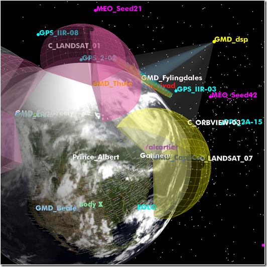
AGI’s 3D globe with the Virtual Earth global satellite and aerial imagery overlaid on it. This particular video shows multiple space systems. The dome projections from the earth represent different radar fields. The video concludes with a zoom in to an unmanned aerial vehicle performing surveillance over an area of interest.
As mentioned before, AGI incorporated core AGI analytical functions into Microsoft Virtual Earth. That means the following capabilities are now possible using AGI and Virtual Earth:
- Terrain constrained line of site
- Sensor projection with terrain
- Sensor overflight times with collection constraints
- GPS navigational accuracy
- Coverage analysis of constellation of sensors
- Aircraft route generation
- Dynamic link budget modeling transmitters and receivers
Also, with regards to, integrating Microsoft Virtual Earth streaming imagery into AGI 3D software products. The benefits include:
- High fidelity imagery and maps streaming from server or appliance
- Base and national imagery
- Removes the need for users to search for and manage globe data
- Aids in analysis by providing better situational understanding of an area of interest on the ground
Check out how the AGI / Virtual Earth integration can be used for flight planning;
This video shows the mission planning demo we built using our development components and the Virtual Earth API. The entire application is run within the browser. It allows pilots or those planning an aircraft mission to create an aircraft route, place a sensor or camera on the aircraft and then compute how well that camera will be able to cover an area of interest that they want to search.
Seriously, every day something new seems to cross my screen with Virtual Earth, but rarely am I so impressed as I have been with this. I figured this would be a nice way to end a very busy week. Enjoy.
CP

