Customizing Clustered Pushpins
Note
Bing Maps Web Control SDK retirement
Bing Maps Web Control SDK is deprecated and will be retired. Free (Basic) account customers can continue to use Bing Maps Web Control SDK until June 30th, 2025. Enterprise account customers can continue to use Bing Maps Web Control SDK until June 30th, 2028. To avoid service disruptions, all implementations using Bing Maps Web Control SDK will need to be updated to use Azure Maps Web SDK by the retirement date that applies to your Bing Maps for Enterprise account type. For detailed migration guidance, see Migrate from Bing Maps Web Control SDK and Migrate Bing Maps Enterprise applications to Azure Maps with GitHub Copilot.
Azure Maps is Microsoft's next-generation maps and geospatial services for developers. Azure Maps has many of the same features as Bing Maps for Enterprise, and more. To get started with Azure Maps, create a free Azure subscription and an Azure Maps account. For more information about azure Maps, see Azure Maps Documentation. For migration guidance, see Bing Maps Migration Overview.
By default, the clustering layer uses the default pushpin and sets the text option to the number of pushpins that are in the cluster. Customizing the clustered pushpins can be done by passing a callback function into the clusteredPinCallback option of the cluster layer. This callback will receive a reference to a ClusterPushpin object which is special pushpin that has a couple of extra properties on it. You can customize the ClusterPushpin the same way you would a standard pushpin, using the setOptions function. For example:
var clusterLayer = new Microsoft.Maps.ClusterLayer(pins, {
    clusteredPinCallback: function (cluster) {
        //Customize clustered pushpin.
        cluster.setOptions({
            icon: '[custom pushpin info]'
        });
    }
});
There are many different ways to customize a pushpin in Bing Maps such as using a URL to an image or SVG file, using inline SVG or a Base64 image string. Documentation on how to create these different types of custom pushpins here.
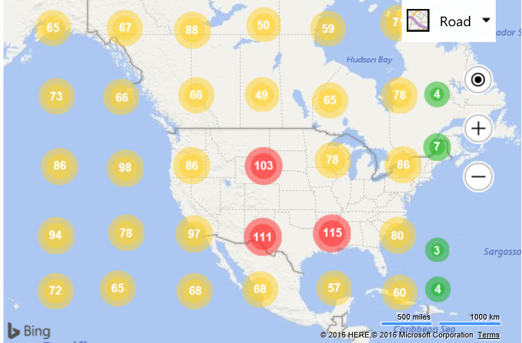
In this code example, instead of simply using a custom image to represent a clustered pushpin, we will see how to dynamically create an inline SVG icon based on the number of pushpins that are in the cluster. Clusters will be represented using a circle. The more pushpins in the cluster the larger the circle will become, using a logarithmic scale. Since the size of the circles will grow, we will increase the grid size used by the clustering layer to accommodate this. Additionally, if a cluster has less than 10 pushpins, the circle will be green, less than 100 pushpins, yellow, more than 100, red.
<!DOCTYPE html>
<html>
<head>
    <title></title>
    <meta charset="utf-8" />
	<script type="text/javascript">
    var map, clusterLayer;

	function GetMap() {
	    map = new Microsoft.Maps.Map('#myMap',{
	        credentials: 'Your Bing Maps Key',
               zoom: 3
	    });

        Microsoft.Maps.loadModule("Microsoft.Maps.Clustering", function () {
            //Generate 3000 random pushpins in the map view.
            var pins = Microsoft.Maps.TestDataGenerator.getPushpins(3000, map.getBounds());

            //Create a ClusterLayer with options and add it to the map.
            clusterLayer = new Microsoft.Maps.ClusterLayer(pins, {
                clusteredPinCallback: createCustomClusteredPin,
                gridSize: 80
            });
            map.layers.insert(clusterLayer);
        });
	}

	function createCustomClusteredPin(cluster) {
	    //Define variables for minimum cluster radius, and how wide the outline area of the circle should be.
	    var minRadius = 12;
	    var outlineWidth = 7;

        //Get the number of pushpins in the cluster
	    var clusterSize = cluster.containedPushpins.length;

        //Calculate the radius of the cluster based on the number of pushpins in the cluster, using a logarithmic scale.
	    var radius = Math.log(clusterSize) / Math.log(10) * 5 + minRadius;

        //Default cluster color is red.
	    var fillColor = 'rgba(255, 40, 40, 0.5)';

	    if (clusterSize < 10) {
	        //Make the cluster green if there are less than 10 pushpins in it.
	        fillColor = 'rgba(20, 180, 20, 0.5)';
	    } else if (clusterSize < 100) {
	        //Make the cluster yellow if there are 10 to 99 pushpins in it.
	        fillColor = 'rgba(255, 210, 40, 0.5)';
	    }

	    //Create an SVG string of two circles, one on top of the other, with the specified radius and color.
	    var svg = ['<svg xmlns="http://www.w3.org/2000/svg" width="', (radius * 2), '" height="', (radius * 2), '">',
            '<circle cx="', radius, '" cy="', radius, '" r="', radius, '" fill="', fillColor, '"/>',
            '<circle cx="', radius, '" cy="', radius, '" r="', radius - outlineWidth, '" fill="', fillColor, '"/>',
            '</svg>'];

	    //Customize the clustered pushpin using the generated SVG and anchor on its center.
	    cluster.setOptions({
	        icon: svg.join(''),
	        anchor: new Microsoft.Maps.Point(radius, radius),
	        textOffset: new Microsoft.Maps.Point(0, radius - 8) //Subtract 8 to compensate for height of text.
	    });
	}
    </script>
    <script type='text/javascript' src='http://www.bing.com/api/maps/mapcontrol?callback=GetMap' async defer></script>
</head>
<body>
    <div id="myMap" style="position:relative;width:600px;height:400px;"></div>
</body>
</html>
Running this code in a browser will cluster 3,000 random pushpins and display them as scaled and colored circles.
