New ESRI / Microsoft Virtual Earth Partnership Announced
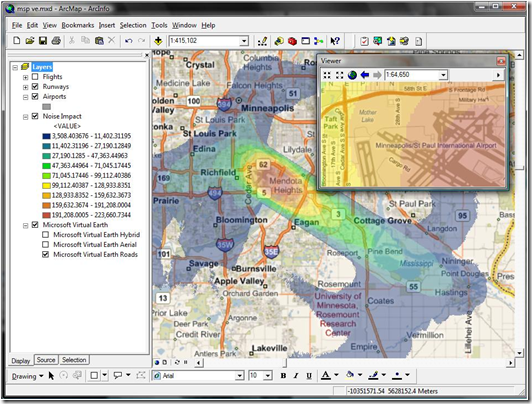
 This week during the Environmental Systems Research Institute Developer Conference in Palm Springs, CA, ESRI announced their extended partnership with Microsoft’s Virtual Earth business unit granting native access to Virtual Earth’s imagery and road network map data within ArcGIS Desktop and Server. How’s that for a footprint? At the very least it makes the GIS world a bit more interesting, no?
Here’s the official announcement:
ESRI Expands Virtual Earth Access in GIS by Teaming with Microsoft
ArcGIS Users to Bring Dynamic Basemaps into Analysis and Service Applications
Redlands, California—March 26, 2009— ESRI announced today anew agreement with Microsoft Corporation that gives ArcGIS users fast access to Microsoft Virtual Earth for their geographic information system (GIS) projects. As part of ArcGIS Online at the ArcGIS 9.3.1 release, ArcGIS Desktop and ArcGIS Server users will be able to connect directly to Virtual Earth and quickly start their GIS projects with ready-to-use content.
"Our agreement with Microsoft defines a pattern of sharing geospatial data on the Web that promises to grow the GIS community," says ESRI President Jack Dangermond. "By bringing Virtual Earth into their GIS projects, people will have a greater opportunity to perform spatial analysis based on dynamic data."
ArcGIS users who are current on maintenance and have an Internet connection will have access to Virtual Earth for a variety of up-to-date mapping content.including aerial imagery, roads, and hybrid (aerial with labels) imagery. With a familiar look, imagery access will appear as another data layer in GIS. The imagery will provide excellent background maps on which users can overlay their operational data. This means users will be able to focus more on their business data than on its context.
For example, an electric utility can layer its distribution line data over a Virtual Earth aerial view of a neighborhood to create a map of its lines and customer connections. This Virtual Earth background layer is useful for editing the company's data and can be easily shared online with other company users.
ArcGIS users can build Web applications that support geospatial services through ArcGIS Server and ArcGIS Web Software Developer Kits (SDKs) , including APIs for JavaScript, Flex, and Microsoft Silverlight. This enables them to provide their clients with access to Virtual Earth content from their applications.
“ESRI and Microsoft share a long history of building geographic information systems solutions that combine both of our companies’ strengths,” said Chris Sampson, director of Virtual Earth at Microsoft. “By integrating Microsoft Virtual Earth across all ESRI ArcGIS products, we can provide our mutual customers with spatial analysis software that has instant access to comprehensive geographic data that can only be found in a software plus services solution.”
ArcGIS Desktop 9.3.1 users who are current on maintenance will be offered access to Virtual Earth at no cost. ArcGIS Server 9.3.1 users will have instant access to a built-in 90-day evaluation of Virtual Earth. After the evaluation ends, ArcGIS Server users will be able to purchase an annual subscription that will be based on transactions.
For more information, visit www.esri.com/agolwhatsnew.
CP
